River discharge measurements with fixed video cameras
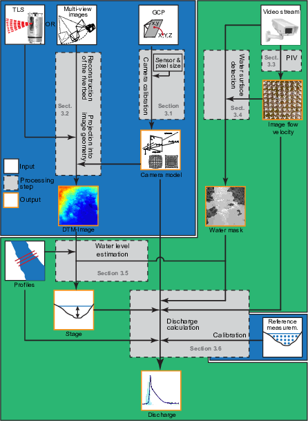
Reliable discharge measurements are indispensable for an effective management of natural water resources and floods. Limitations of classical current meter profiling and stage-discharge ratings have stimulated the development of more accurate and efficient gauging techniques such as nonintrusive photogrammetric techniques. Despite many successful applications of large-scale particle image velocimetry (LSPIV) for short-term measurements during flood events, there are still very few studies that address its use for long-term monitoring of small mountain rivers. To fill this gap, this study targets the development and testing of largely autonomous photogrammetric discharge measurement system with a special focus on the application to small mountain river with high discharge variability in the tropics. It proposes several enhancements concerning camera calibration, more efficient processing in image geometry, the automatic detection of the water level as well as the statistical calibration and estimation of the discharge from multiple profiles. A case study which comprises the analysis of several thousand videos spanning over 2.5 year is carried out to test the robustness and accuracy of different processing steps. Comparisons against classical current meter profiling show a mean absolute percentage error of 9.0% after the statistical calibration of the system. The study suggests that LSPIV can already be considered as a valuable tool for the monitoring of torrential flows, whereas further research is still needed to fully integrate nighttime observation and stereophotogrammetric capabilities.
The repository comprises the Matlab implementation of most methods used in the study and demos to reproduce some of the obtained results.
Publication: Stumpf, A., E. Augereau, C. Delacourt, and J. Bonnier (2016), Photogrammetric discharge monitoring of small tropical mountain rivers: A case study at Rivière des Pluies, Réunion Island, Water Resour. Res., 52, 4550–4570, doi: 10.1002/2015WR018292.